From time immemorial, waterways have been connecting places around the world. A highly developed canal system was typical for the ancient civilisations in areas such as the Nile and the Euphrates and Tigris. The canals made it possible to effectively transport heavy loads and large volumes at a low cost of energy. As a comparison, one can look at what a single horse is capable of carrying or drawing:
100 kg (horse)
2,000 kg (carriage)
10,000 kg (rails)
70,000 kg (canal)
Driving force
An improved economics of transport has almost always been the driving force behind the canal project. In a letter to King Sten Sture the Younger in 1516, former Linköping bishop Hans Brask (1464 - 1538) proposed that the canal "shall cut between Lake Vättern and the Baltic Sea." In 1526, the proposal is again addressed by Hans Brask; this time to Thure Jönsson Tre Rosor. By now, Lake Vänern has been included in the proposal. Hans Brask writes, "A path shall be cut between Lake Vättern and Lake Vänern…". In his letter, he emphasises how the trade and commerce and the defence of the kingdom would profit greatly from such a canal route.
The Sound (Öresund)
Another argument for a canal through the region of Götaland (Västergötland + Östergötland) was that one would thereby avoid paying a toll in the sound of Öresund, between Denmark and the present-day Sweden. (The southern region of the Sweden, known as Skĺne, belonged to Denmark at that time.) This duty on trade had existed since 1429. It was, to say the least, a constant source of irritation for the Swedes. The duty was imposed on all passing vessels and collected at the duty office, which was located in Helsingör (opposite present-day Helsingborg, Sweden).
The canals - the first infrastructure system
King Gustav I Vasa also realised the advantages of a canal, but a canal project was never organised in his time. During the period called "Stormaktstiden," traditionally considered to date from Gustav II Adolf's ascending of the throne (1611) to the death of Karl XII (1718), the discussions were centred around the building of the canal in the river Göta Älv in order to improve the economics of transportation of the mining industry.
It was not until the 18th century that the canal project in Sweden began to take form. Inspired by the great expansion in canal building in England, the Swedes began planning what would later become the first infrastructure system in Sweden. This network would consist of canals that would connect Lake Vänern, Lake Vättern, Lake Mälaren (west of Stockholm) and Lake Hjälmaren (east of Örebro). The State would be in charge of building these larger, connecting canals, while private companies would be responsible for building the smaller, feeder canals.
Discord between Söderköping and Norrköping
In 1740 the social classes represented in the Swedish Parliament, called "ständer," i.e. farmers, bourgeoisie, priests and aristocrats, took a decision to build a naval waterway between Lake Vättern and Norrköping. Thoroughly disatisfied with the decision, Linköping bishop Anreas Rhyzelius appealed for building the Göta Canal between Lake Vättern and Söderköping. Considerable quarrelling arose in the Parliament between the bourgeoisie in Söderköping and Norrköping.
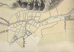
In 1754 surveying engineers Jonas Collin and Olof Garn were contracted to explore the possibilities of a waterway with locks between Lake Vättern and Norrköping. One of their maps (below) is presented under Canal Maps/Borensberg.
 However, the magistrate of Söderköping was persistent in his efforts. After a prolonged period of lobbying, the Parliament reversed its decision in 1772 and conferred the mouth of the canal to Söderköping. At the same time, King Gustav III appointed Carl Fredrik von Röök who was head billetting officer of the Swedish army, to make a new comprehensive Göta Canal proposal. Von Röök presented his canal proposal in 1774, a section of which is presented under Canal Maps/Östergötland. VonRöök was assisted by the artistically inclined cartographer and conductor Eric Myhrén, from the central fortification administration. Von Röök's proposal was based on the observations of Jonas Collin. In regard to the location of the mouth of the canal, he weighed the respective alternatives of Norrköping and Söderköping and decided in favour of Söderköping.
New canal-building techniques
Von Röök's canal proposal was based on the old canal-building techniques. These involved the utilisation of natural streams. After a technical breakthrough, around 1780, a new technique was introduced. The necessary locks were to instead be grouped together in lock stairways. The stretches of the canal would follow the contour line. The use of this new technique meant lower building and maintenance costs as well as improved transportation economics.
(See also: Wet-digging method och Dry-digging method)
New canal technique is adopted
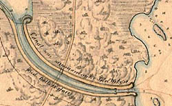
One of the advocates of the new canal technique was lockbuilder Daniel Thunberg, who had helped build the Trollhätte Canal, in western Sweden. He sharply criticised and rejected von Röök's canal proposal. Afterwards, Thunberg, himself, was commissioned to present a new canal proposal. This time, the proposal was to account for the whole of the stretch between Lake Vänern and the Baltic Sea. (See Canal Maps/Västergötland)
On some of the general maps, for example, Canal Maps/Borenshult, one can see both von Röök's and Thunberg's canal proposals.
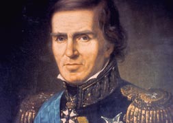 Baltzar von Platen takes the stage
After an unusually short career in the navy, Baltzar von Platen resigned in 1797 at the rank of admiral. The following year, he settled in the manor of Frugĺrden, on Vänersnäs Point. The first time that von Platen came into contact with the building of the canal was in 1795, after he had observed the building of the Trollhätte Canal. This feat made a very strong impression on him. Three years later, in 1798, he was elected onto the Board of the Trollhätte Canal. Consequently, he established close contacts with the leading canal engineerings of that time. His enthusiasm continued, and in 1806 he published a work entitled "Dissertation on Canals through Sweden, in regard to the joining of Wenern with the Baltic."
Von Platen was in support of the increasingly accepted proposal from 1784 by Daniel Thunberg. With an iron will, von Platen strived to establish the Göta Canal as a natural continuation of the Trollhätte Canal, which was inaugurated in 1800. He then travelled to Scotland, France and Germany to study how canal building was being done abroad. He was especially impressed by the French-built Canal du Midi. The canal was completed in 1681 and has a difference in altitude of over 200 metres. In 1808, von Platen received the support of King Gustav IV Adolf to "undertake and complete the national task for the sake of the Kingdom of Sweden."
Brittish canal builder Thomas Telford inspects canal
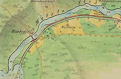 In August 1808, an invitation was sent to the famous canal builder from England Thomas Telford, requesting his presence in Sweden to inspect and approve the stretch of canal drawn by Daniel Thunberg. Only minor changes were made to the proposal. These were notably marked with a red pencil. (See Husbyfjöl, right)
Telford was also assigned the task of estimating the costs of building the Göta Canal.
Building permit comes by a Royal Charter
In Parliament, a Linköping bishop once again became one of the main figures involved in the discussions about the Göta Canal. On this occasion, it was Carl von Rosenstein who, in 1809, put forward a motion in regard to the canal. A heated discussion ensued. The newly enthroned king, Karl XIV Johan, acted in favour of Baltzar von Platen. On 10 October 1809, an official letter was remitted by the Parliament to the king, requesting approval to start the building of the canal.
On 11 April 1810, a royal charter for "Göta Canal Company," was issued "by the grace of His Majesty the King." A month later, building of the canal was officially started in Motala, on the Östergötland side, and in Forsvik, on the Västergötland side. The building of Sweden's Grand Canal was finally underway!
 An Historic Canal