kartamot.gif (16759 bytes)


Motala Lock and Bridges
< Westwards | Vadstena | Motala Lock and Bridges
Borenshult Lock and Bridge | Eastwards >

vala023156_motala_hori_250.jpg (11803 bytes)The bridge at Motala served as an important crossing over the river Motala Ström for travellers in a north-south direction. There were even good fishing places along the foot of the bridge. Water-driven mills, tramples and sawmills could also be found here.

As far as the amount of water was concerned, there was never the need to worry about a lack of water since Lake Vättern is the "storehouse" for the eastern section of the Göta Canal. All of the project leaders seem to have been in agreement on this.

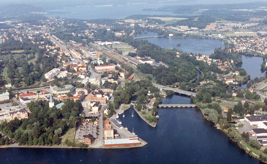
The year 1810 marked the official beginning of the building of the canal. Commencement activities were held in Motala. According to Baltzar von Platen, Motala was to be the location of the head office of the canal company AB Göta kanalbolag. Plans also included the building of the Motala Verkstad, a workshop that functioned as the maintenance workshop for the building of the canal. The workshop is considered the cradle of the Swedish workshop industry. Von Platon's plans also included the establishing of a chain of developing towns along the canal - Motala, Sjötorp, Lyrestad and Töreboda. Motala quickly expanded and in 1881 officially became a town.

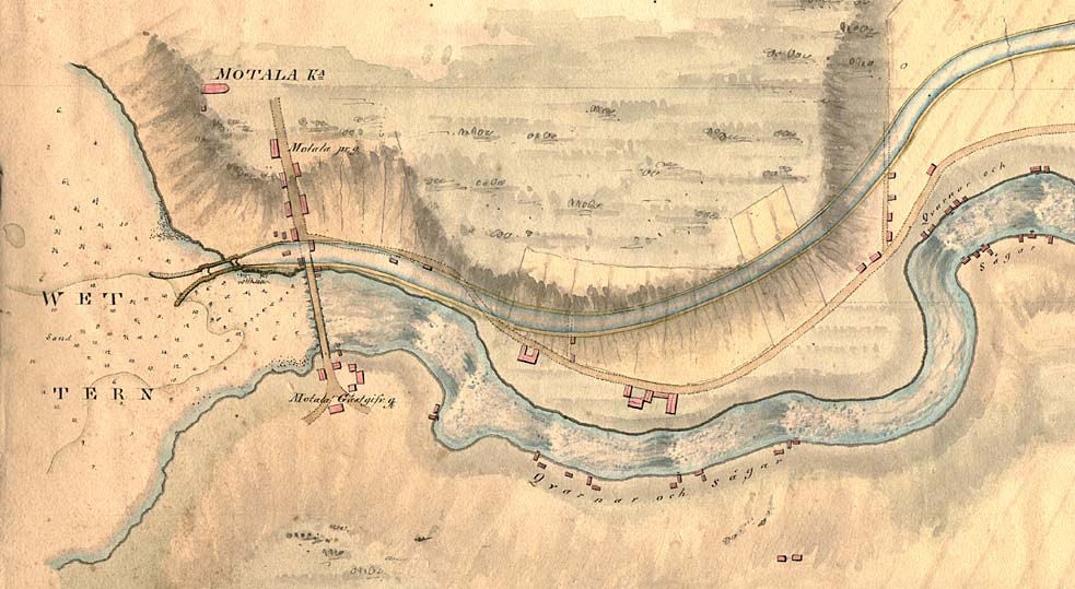
Baltzar von Platen died on 6 December 1829 and is buried "on the bank he himself has built," close to the Motala Harbour. The nearest lock stairway, located in Borenshult, was given the name the "Remembrance" Locks. Up to this day, eastbound vessels still honour the creator of the Göta Canal with a signal.

On the above canal proposal from 1774, the canal is joined to Lake Vättern on the northern bank of the river Motala Ström. This is the same as the present-day construction.

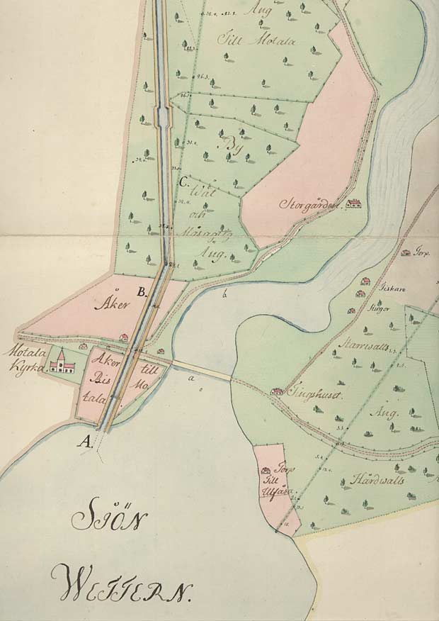
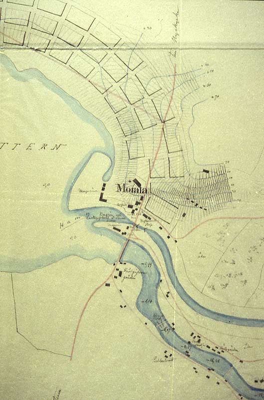
A good reference point on the map is Motala Church. The bridge on the Motala Ström and connecting roads are also clearly marked on the map.

Click on the maps to enlargen! Use the "Back" button to return.


Other maps of the area:
thbg_I16_vat-bor.jpg (61885 bytes) General map from 1784 that shows the present-day stretches of canal between Lake Boren and Lake Vättern.
telf_III11_1808_motala.jpg (99526 bytes) Canal proposal of 1808, showing the joining of the canal to Lake Vättern. Plans were made to build two cornet-shaped jetties leading out into the lake from an equalising lock.

The various streams in Motala with the neighbouring buildings marked "Qvarnar och Sågar" (Mills and Sawmills) are identified in detail.

telf_III11_1808_charlottenb.jpg (95545 bytes) Continuation of the map above, in the direction of current, 1808
Kai183mo_stadsplan.jpg (65123 bytes) On this map from the 1830s, one can see how the proposal from 1808 has been modified. A harbour with docks and a storehouse have been built. The equalising lock has even been moved.

The well-known fan-shaped design for the town of Motala has been drawn on the map but at this point has not been realised (KrA).

motala_flyg.jpg (97589 bytes) Aerial photo of Motala and the harbour entrance towards Lake Vättern

Source: County Administrative Board in Östergötland, Cultural Environment Office

Photo: Jan Norrman, the Swedish Central Board of Antiquities, 1991

motala_bro_kai831mb.jpg (18629 bytes) Design for the bridge Storbron, with nine arches, on the river Motala Ström. Before the construction of the bridge got underway, authorities in Jönköping expressed their concern that the bridge would have a damming effect on the water level of Lake Vättern. An increase in the water level could possibly result in the flooding of the low-lying areas of Jönköping.
motala_bro_foto.jpg (23347 bytes) Storbron Bridge and the outlet of Lake Vättern (right) and the inlet into the Göta Canal (left)
motalaverkstad_flyg.jpg (101442 bytes) Aerial photo (eastwards) of the park-like passage of the canal through Motala and the workshop island, with Motala Verkstad to the right.

Source: County Administrative Board in Östergötland, Cultural Environment Office.

Photo: Jan Norrman, the Swedish Central Board of Antiquities, 1991

motala_torrdockan_foto.jpg (13397 bytes) One of the three dry docks built on the Göta Canal is located here. It is connected to the Motala Verkstad. The building and repairing of canal vessels took place here at the workshops.
turist_vadstena-borenshult.jpg (138682 bytes) General map of the stretch of canal between Vadstena and Borenshult.

(AB Göta kanal Tourist Map: Eastern Section, 1995).

Blue line = Gothenburg - Stockholm route of the Göta Canal used by the firm of shipowners Rederi AB Göta kanal.

Red line = bicycle path.